Three Acronyms of the Spatial World
Answer this question: What technologies are you using today that you never thought you would use? Remember when architects (of all people) used to argue that CAD would never be widely adopted in the industry? You may have been one to try to reason with them (you may be one of those architects). What has changed? What was once debatable is now a reality. In light of this we argue: Are technologies that are now being widely adopted (such as BIM), and the integration of these really a legitimate topic of debate? Let me be clear: If you are not on the technology train, you may be left at the station, attempting to redevelop your business plan, while you watch others profit from your delay. So now, if you know you need assistance for this part of your business, ask the appropriate industry leads for assistance. If you couldn't before because of uncertainty or ignorance, Javaknight is offering both knowledge and capability. . . . so now you can. Here are some of the ways you can, with the three acronyms of the spatial world:
Computer Aided Drafting or Design (CAD) - Many of us are not only still using CAD (we won't hold that against you) but doing awesome things with it. CAFM systems are still, for the most part, built on CAD. GIS is done in CAD with tools such as Autodesk Map. CAD is used throughout the trades for construction and numerous others are all using CAD. Javaknight is an expert in both CAD and (the Javaknight market niche) CAD integration. There is no reason why CAD, BIM and GIS should not be able to used in one environment. Standards, protocols and rules should be in place to allow this both in a business and technical way. Javaknight creates these, and we can create them for you.
Building Information Modeling (BIM) - Some of us have been using BIM since the 80's (perhaps with ArchiCAD -- remember the virtual building), I however am a latecomer, I started in the late 90's. Since then I have seen BIM become prolific in name only, not in functionality. All "BIM" solutions are not really information modeling. True all of them allow a measure of information to be modeled. But, as an integrator, I don't just assist to architect buildings, I architect enterprises. While few BIM tools allow this, Javaknight knows how to make all of them deliver information to the enterprise to be modeled, managed and maintained, as the above illustration endeavors to convey in a simple way. Need a building modeled, contact us. Need information architected, contact us. Need to know why: Because your internal and external clients need your information flowing, to save you (and them) money. . . . and now you can.
Geographic Information Systems (GIS) - Javaknight was, at one time, a government employee. The title, Geographic Information Systems Program Manager for the National Capitol Region. My function was simply to integrate CAD, BIM and GIS data from facilities into as many enterprise apps and business lines as I could. Successful? In three years, users of solutions developed by Javaknight went from 12 to 187 in an agency that was email averse. The point: If you need GIS and facilities data not only to talk but also to thrive, then you also need Javaknight.
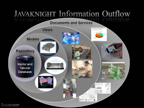
Javaknight Information Access Vision: Take a look at the above diagram that has been modified from one produced by one of the federal agencies. The idea is that critical information should be able to be stored in an information repository accessible to the entirety of the business. The image on the extreme left is a database of vector and tabular information. Perhaps with a series of BIMs, CAD or Geospatial (GIS) data. Querying this data on the model level should produce. . . well. . . . a model. Using tools such as Oracle Spatial, MS SQL Server, BIM Server, The Onuma System and Objective World's BIM Server/Integrator, this is possible. The next two levels demonstrate how this architecture allows the BIM or Spatial data to be viewed in ways that each business community needs it, without being an engineer or an architect. Whether you are in Finance, Emergency Management, Master Planning or an Engineer. Could your business use this level of clarity? Well if you couldn't before, now you can.